Winter Storm Watch, Advisory Issued For Quad City Communities Ahead Of Thursday’s Storm

It's no secret; nasty weather is headed our way late tonight into early Friday morning that will bring blizzard like conditions and more snow.
According to the National Weather Service of the Quad Cities, a fast moving Arctic cold front will bring potentially dangerous conditions to the QCA Thursday and Thursday night. Early Thursday morning, we'll be seeing rain, possibly mixed with freezing rain and sleet will move into eastern Iowa.
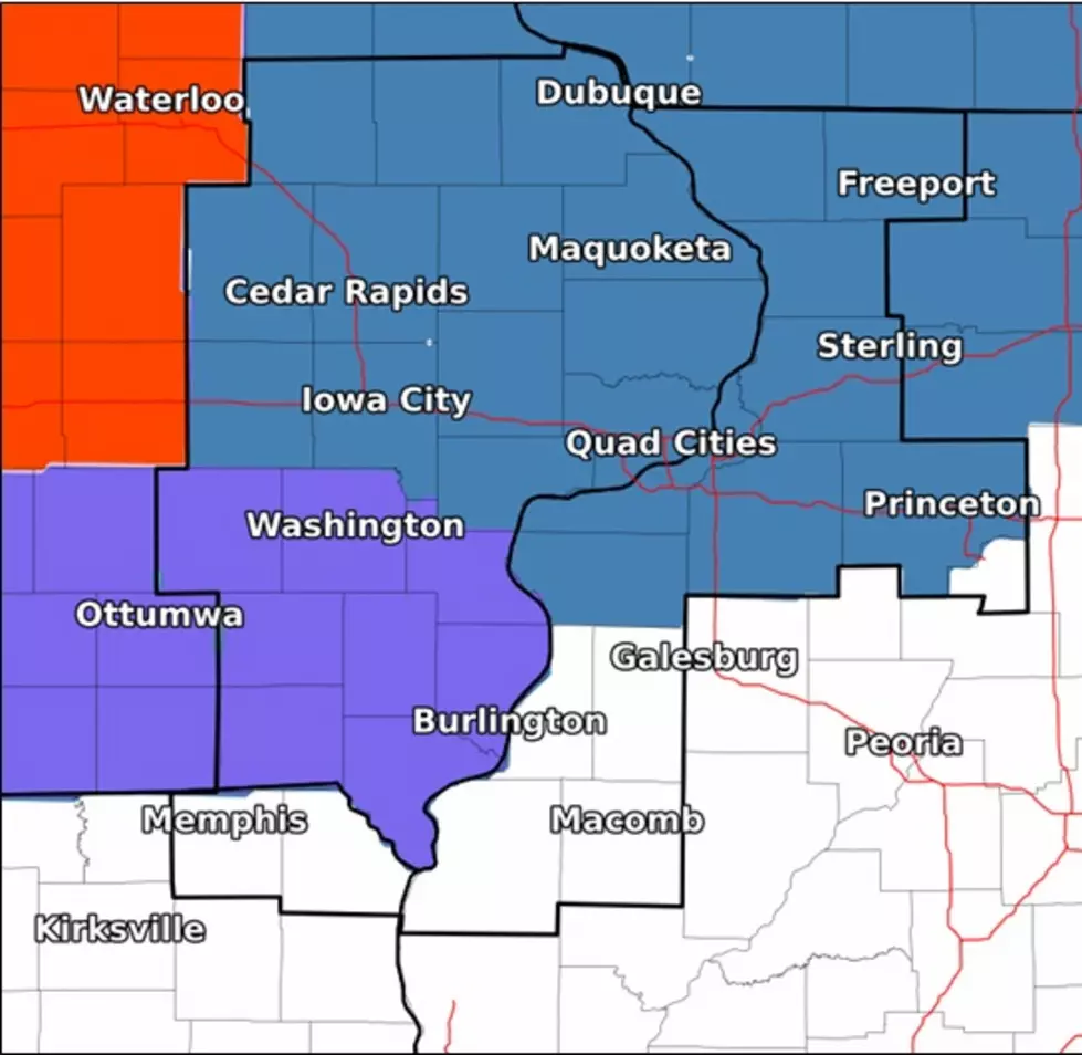
Behind that storm will be a cold front which is going to cause Old Man Winter to wreak havoc throughout the area. This nasty weather has put some of us in a Winter Storm Watch and others in a Winter Weather Advisory.

As the cold front moves in during mid Thursday morning, rain will switch to snow. Officials from the NWS say that snow is expected to fall for several hours behind the cold front, with several inches expected to fall. We could see snowfall totals range from a trace to 4" in the immediate and surrounding Quad City area.
Snowfall totals decrease the more south you go, but a Winter Weather Advisory has been issued for majority of southeast Iowa counties.

Whether your area sees a lot or not that much snow, the winds are going to be blowing it and past snow on the ground around like crazy. We'll see temps start to drop and winds increase to a steady 30 mph. Those two factors will cause any wet roads to flash freeze.
As the cold front moves through, winds behind the front will increase to 25 to 35 mph with gusts up to 40 mph. This will cause a lot of blowing snow, which will be dangerous in open areas.
Officials say that white out conditions are possible, and some areas in Iowa may experience several hours of blizzard conditions.
Significant drifting snow will be a problem through Thursday night causing hazardous road conditions.
This is the current forecast for Thursday into Friday morning according to the NWS of the Quad Cities:
- Thursday
- Rain, freezing rain, and sleet before 1pm, then rain and snow between 1pm and 3pm, then snow after 3pm.
- Temperature falling to around 31 by 5pm.
- South wind 10 to 15 mph becoming west in the afternoon. Winds could gust as high as 25 mph.
- Chance of precipitation is 100%.
- Little or no ice accumulation expected. New snow and sleet accumulation of 1 to 2 inches possible.
- Thursday Night
- Snow, mainly before 10pm.
- Patchy blowing snow.
- Low around 10.
- Wind chill values as low as -10.
- Blustery, with a west wind 20 to 25 mph, with gusts as high as 35 mph.
- Chance of precipitation is 90%.
- New snow accumulation of less than a half inch possible.
- Friday
- Areas of blowing snow before 7am.
- Partly sunny, with a high near 15.
- Breezy.
Counties under a Winter Storm Watch
| Iowa | Illinois |
| Buchanan | Jo Daviess |
| Delaware | Rock Island |
| Dubuque | Stephenson |
| Benton | Carroll |
| Linn | Whiteside |
| Jones | Henry |
| Jackson | Bureau |
| Iowa | Mercer |
| Johnson | |
| Cedar | |
| Clinton | |
| Muscatine | |
| Scott |
Counties under a Winter Weather Advisory
| Iowa |
| Keokuk |
| Washington |
| Louisa |
| Jefferson |
| Henry |
| Des Moines |
| Van Buren |
| Lee |
We will keep you up to date on snowfall totals after the snow moves through the area Thursday into Friday morning.
Extremely cold temperatures are expected to come to the area over the weekend and early part of next week. We'll keep you updated on that as we get closer to the weekend.
More From B100


